
Don’t Hit the Panic Button: East Pacific Tropics, Warm Water, and Why SoCal Fishing Stays Spectacular
Every September the East Pacific lights up, the social-media panic button gets mashed in Southern California, and somebody swears a hurricane is “coming up the coast.” Let’s talk like fishermen, not like the weather channel.
As of Sunday afternoon, September 20, 2026, the National Hurricane Center is tracking two live systems in our ocean — and neither one is a threat to Seal Beach, San Diego, or the Channel Islands.
What’s actually out there
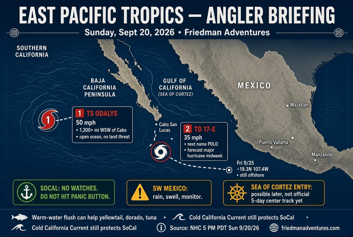
Tropical Storm Odalys is the far-away one. She’s about 1,300 miles west-southwest of Cabo San Lucas, already at 50 mph, and forecast to become a hurricane as soon as Monday. Her job is to wander around open ocean. The official track keeps her well offshore. No watches. No warnings. No reason to cancel a local trip because of Odalys.
The one that matters to Mexico — and maybe later to Baja — is brand new Tropical Depression Seventeen-E, sitting a few hundred miles south of Manzanillo. Winds 35 mph. Next name on the list is Polo. NHC says she becomes a tropical storm Monday, a hurricane Tuesday, and a major hurricane by midweek, with 115 mph winds still on the table Friday.
That’s the swirl a lot of you are seeing on Windy for Friday the 25th. You’re not imagining it.
The track — and what it is not
Official forecast points through Friday put 17-E near 19.3°N, 107.4°W — still offshore, south of the tip of Baja, west of the mainland, approaching the approaches to the Gulf of California, not parked in the Sea of Cortez. Closest official look at Baja California Sur by Friday is still a few hundred miles. NHC wind probabilities for Cabo San Lucas are only about 9 percent for tropical-storm-force winds in the five-day window. Islas Marías is higher. Southwest Mexico (Michoacán, Colima, Jalisco) is the area that needs to watch rain, surf, and mudslides this week — 4 to 8 inches, isolated 12.
Swell from this system is expected to work north to Baja California Sur by the end of the week. That’s a sea state issue for pangas and small boats around the Cape, not a hurricane landfall in Orange County.
Tracks this far out still wiggle. If later advisories hook her more north into the mouth of the Gulf, we’ll say so. Right now the official center is not forecast to run up the Sea of Cortez as a hurricane.
Do hurricanes actually go up the Sea of Cortez?
Yes — but it’s the exception, not the commute.
Most East Pacific storms are born south of Mexico and get steered west or west-northwest into open ocean. Research on historical tracks puts the “turns north and actually enters the Gulf of California” group at only about 2 percent of the basin’s cyclones. Rare. Not a unicorn.
When it does happen, fishermen in the Cortez remember it. Hurricane Ismael in 1995 ran the Gulf and killed dozens of fishermen. Marty (2003) and Newton (2016) crossed into the Gulf after hitting the Cape. Liza (1976) is still a bad memory in La Paz. In 2018 a depression even formed inside the Gulf — first time on record. So if a future advisory starts pointing 17-E / Polo up the Cortez, take it seriously for Sinaloa, Sonora, the East Cape, and anyone running small boats between the islands. Just don’t pretend that’s the normal path.
The warm-water question — this is the part that matters to us
A lot of anglers believe these storms flush warmer water up northern Baja and into Southern California, and that the bite stays wide open because of it. There’s truth in that, and there’s also a lot of wishful thinking.
Storms that hook more north than west can shove a pulse of tropical water and tropical moisture up the outside of Baja. Skippers have said it for years: when the Cape gets worked and the storms don’t just run straight at Hawaii, you often see better odds of dorado, yellowfin, and that late-season yellowtail spread hanging around longer. El Niño years already bias the East Pacific hot and busy — this 2026 season is running ahead of normal on named storms — and that same warm basin is why local fishing has been as good as many of us have seen in a long time.
What these storms do not do is pick up the Sea of Cortez and pour it onto the Huntington Beach pier. The cold California Current is still the wall. That’s why California almost never takes a hurricane hit — last hurricane landfall on the U.S. West Coast is 1858, last tropical-storm landfall 1939. Moisture can sneak north as remnants. Wind and surf can get sloppy. The fish do not evacuate Orange County.
So keep fishing. Watch SST breaks, kelp, and bait like you always do. If a northbound storm adds a little extra warmth on the Baja banks, we’ll take it. That’s a gift, not a guarantee.
Who should actually worry
• Southwest Mexico this week: rain and surf. Respect it.
• Baja California Sur late week: deteriorating offshore seas, not a SoCal evacuation.
• Sea of Cortez communities: stay tuned. A Gulf entry is possible later. It is not the official 5-day center track today.
• Southern California: no watches, no warnings, no reason to sit on the couch. If you were going to hit the panic button, put it back.
I’ll keep watching the 5 p.m. and 11 p.m. NHC packages the same way I watch a morning bait report. When the track changes, we talk about it. Until then, the East Pacific is doing what a busy El Niño September does — and the fishable water from the Channel Islands to northern Baja is still the story.
Check http://friedmanadventures.com for Captain’s audios, landing and boat counts, bait availability, Friedman Adventures AI, kids corner, and lots more.
https://friedmanadventures.com
National Hurricane Center: https://www.hurricanes.gov
#FriedmanAdventures #EastPacific #TropicalUpdate #HurricaneSeason #TropicalStormOdalys #TD17E #Polo #BajaFishing #SeaOfCortez #GulfOfCalifornia #Cabo #SoCalFishing #Yellowtail #Dorado #ElNino2026 #DontHitThePanicButton #Sportfishing #MexicoFishing #ChannelIslands #HooksLanding #Estella #FishingReport